In June of 2021, the U.S. Geological Survey completed and made available the Global Mountain Explorer Version 2.0. The Global Mountain Explorer (GME) is a web-based visualization and query tool which allows the online exploration of three terrain-based characterizations of global mountain extent. These characterizations are often referred to as K1, K2, and K3, according to the last name of the first author of the research paper which presented the respective analysis.
K1 refers to the characterization of Kapos et al. (2000), and represents a resource produced by the UNEP World Conservation Monitoring Center (WCMC). K2 refers to the characterization of Koerner et al. (2011), and is associated with the Global Mountain Biodiversity Assessment (GMBA). K3, meanwhile, refers to the characterization by Karagulle et al. (2017), and was developed by Esri and the U.S. Geological Survey. The GME is a map-centric tool which allows users to query any location on Earth and identify whether or not it is mountainous according to the three delineations. The map viewer has a wide range of functionality, including pan and zoom, making location queries split-screen pairwise comparisons, conducting text searches on place names, and displaying of the mountain areas over a variety of basemaps including satellite imagery and topographic maps. Further information on K1, K2, and K3, as well as the GME 1.0, is provided in a paper in Mountain Research and Development by Sayre et al. (2018).
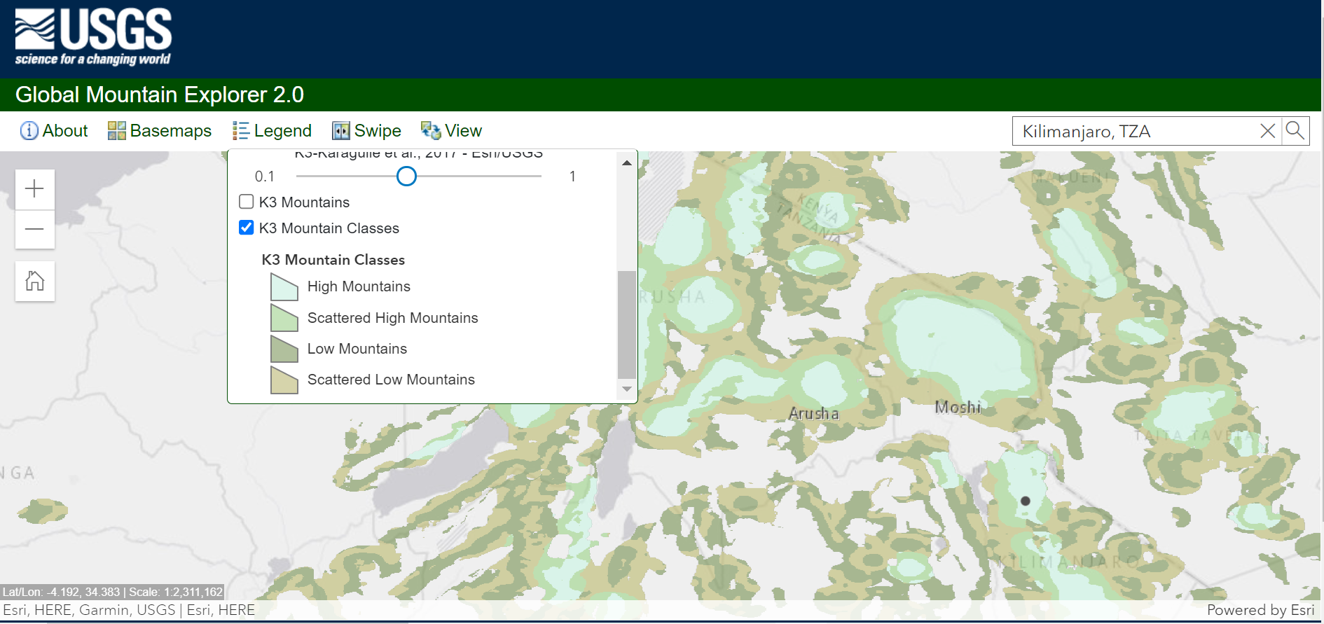
Pictured: Screen capture of the upgraded Global Mountain Explorer tool.
Many of the changes in GME 2.0 are technological improvements relating to platform and performance enhancements, and are not visually apparent to the user. The biggest change, however, relates to content. GME 1.0 contained layers for K1 and K2 that downscaled (resampled to increased spatial resolution) in an attempt to make them more comparable with the higher resolution K3. We found that our downscaled layers for K1 and K2 caused the area of total global mountain extent to vary considerably from what was reported in the original publications. Discussion with the authors and their organizations resulted in a collective decision that the GME 2.0 would be reframed on the original, non-resampled versions of K1 and K2. GME 2.0 therefore presents the original non-resampled versions of K1 and K2 (or recreations thereof) in the viewer and makes these resources available download. Users of the K1 and K2 resources downloaded from the GME prior to June 2021 should be aware that those layers were downscaled and report a different global mountain extent area than the original publications.
Importantly, when using Digital Elevation Models (DEMs) to compute terrain characteristics, the choice of the neighborhood analysis window (NAW) size for raster processing influences the area identified as mountainous by any definition. Selection and evaluation of NAW sizes, elevation criteria, ruggedness thresholds, etc. is always arbitrary and empirical, and the interactions of these parameters with increasingly fine DEM spatial resolutions is complex, rendering terrain-based determination of global mountain extent a very nuanced undertaking.
Finally, the GME is considered a contribution to GEO Mountains, and the new GEO Mountains logo is included in the banner. The work of Jill Cress of the U.S. Geological Survey, who developed both the original GME 1.0 and its upgrade to GME 2.0, is gratefully acknowledged.

![]()
![]()
![]()
![]()
![]()
This article was provided by Roger Sayre, U.S. Geological Survey.