Regional Centre for Mapping of Resources for Development (RCMRD) (Kenya) & NASA (USA)
Arid and semi-arid rangelands support a significant portion of the world's human population and biodiversity. Yet these landscapes are threatened by degradation, through loss of vegetation, increasing spread of invasive or undesirable species, or both. Efforts to halt or reverse degradation exist, but lack of monitoring and reporting of restoration outcomes hampers efforts to replicate and upscale effective practices to other areas.
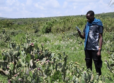
In this context, the project first conducted field surveys in the Mt. Kenya region to map land cover types and invasive species. Three invasive species – Acacia reficiens, Opuntia, and Sansevieria – were observed. Then, focusing on five counties in the study region which have been heavily affected by two of the species (Acacia reficiens and Sansevieria), reducing forage spaces for livestock and wildlife, a Random Forest model was established to derive land cover / land use classifications and their changes through time (from 2000 to 2022). The results show that forests and wooded and open grasslands have been converted to cropland and infrastructure.
Finally, various statistical modelling techniques – namely Generalized Additive Models, Generalized Linear Models, and Generalized Boosted Regression Models – were applied to analyse and interpret the relationships between species occurrence and environmental variables, and to make projections under future climate scenarios. The results indicate that warming temperatures provide more suitable conditions for the survival of the invasive species. Indeed, most parts of the study areas maybe occupied by the invasive species by 2050 if no actions are taken reduce the greenhouse emissions, highlighting a need to formulate adaptation and mitigation measures to protect vast landscapes and local communities from loss of biodiversity associated with climate change.
Main outputs:
The main output of the project is a GitHub repository which contains the data, scripts, and plots.
The resources generated by the project will be included in the next version of the GEO Mountains General Inventory.
Contact: Dr. Edward Ouko, Theme Lead – Ecosystems and Landscapes, RCMRD: eouko [at] rcmrd.org
Image from Edward Ouko