This project used 20 years of climate data from a transect of 22 stations across Mount Kilimanjaro to show that high elevations are warming faster, affecting snow, ice, and water availability. Field surveys, satellite-based modelling, and community engagement on the lower slopes provided insights into how climate and land cover changes are impacting water resources and local livelihoods.
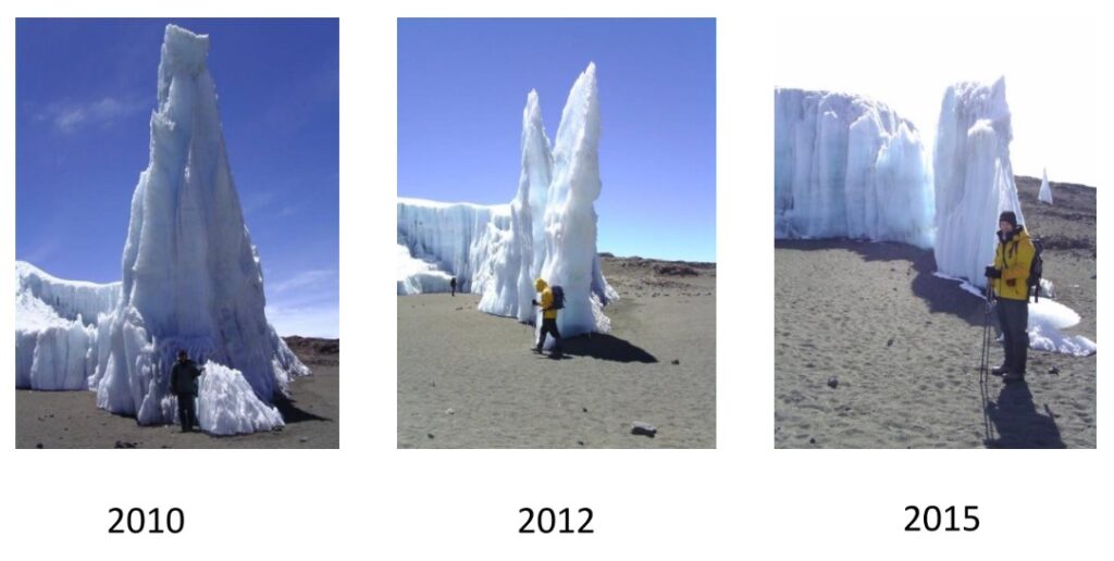
Glaciers and snowfields on Mount Kilimanjaro have been declining for over 40 years, while water pressures and forest fires have increased on the lower slopes. This project aims to assess how temperature and moisture have changed across the full elevation gradient (900–5,800m a.s.l.) and their impacts on water availability and local communities. The team maintained and downloaded data from a 22-station transect spanning the mountain, collecting in-situ observations for 20 years, and used satellite data to model temperature and moisture patterns. Engagement with farmers included interviews, surveys of agricultural practices, and georeferenced photography to understand how climate and land cover changes affect hydrological systems and livelihoods.
Key Activities & Output
- Analysis of 20 years of climate data revealed strong elevation-dependent warming, with high-elevation sites warming most consistently and a strong relationship with ENSO events.
- Development and validation of a model predicting air temperature from MODIS land surface temperature and other variables, enabling spatially extensive analyses.
- Collection of georeferenced agricultural and water-use data, providing insights into local impacts of climate change.
- Three papers in preparation, targeting journals including International Journal of Climatology, Journal of Geophysical Research: Atmospheres, and International Journal of Remote Sensing.
- Outreach activities included an interactive website for visualising climate data and sessions at Moshi International School, engaging over 200 students in understanding environmental change.
- Presentations at international conferences highlighted elevation-dependent warming, climate modelling, and impacts on water resources.
Next Steps
Continued maintenance of the transect is planned, with a focus on transferring operation to local academics and scientists. Proposed future work includes PhD-led studies on the impacts of climate change on livelihoods, expansion of the dataset, and further integration of hydrological and social science components.
Contact
Dr Nick Pepin, University of Portsmouth: Nicholas.pepin [at] port.ac.uk
Supported by GEO Mountains under the Swiss Agency for Development and Cooperation (SDC), Adaptation at Altitude Programme (Project Number: 7F-10208.02.01).