Scientists from the University of Trento, IUSS Pavia and EURAC Research have created a new observational dataset gathering in situ daily measurements of air temperature and precipitation from a variety of meteorological and hydrological services covering the whole European Alpine Region (EEAR).
The data include time series of diverse lengths up to 2020, with the longest records spanning up to 200 years. The dataset aims to serve as a powerful tool to better understand climate change and climatic variability over the European Alps.
Challenges in Monitoring Mountain Climate Change
Climate warming is accelerating in mountain regions, with the European Alps identified as particularly sensitive to these changes. Assessing climate change in this region largely depends on the analysis of long-term climate observations, which are supported by a relatively dense network of weather stations and extended time series conditions rarely met in other mountainous areas worldwide. However, the fragmentation of station ownership, the limitations in data sharing and the heterogeneity of data sources pose significant challenges to the collection, harmonization, and management of these datasets. To address these limitations, various meteorological datasets have been developed across Europe in recent decades. These efforts have mainly focused on improving data quality, temporal resolution, temporal coverage or spatial density, though the development of observational dataset combining all these improvements is still hard to attain, especially for multi-variable products. This highlights the ongoing need for high-quality observational data to better understand climate dynamics, particularly in terms of change and variability.
Given the current limitations of existing observational datasets for the Alpine region, enhancing data quality and integration is essential for advancing our understanding of climate change impacts in this area. Therefore, the primary goal of this study is to develop a new, comprehensive observational dataset for the European Alps. This dataset aims to resolve critical issues related to data quality, spatial and temporal resolution, and completeness, thereby offering an unprecedented resource for climate analysis in this highly vulnerable region.
Data Collection and Methods
EEAR-Clim includes daily time series up to 2020 for mean, minimum, and maximum, air temperature (T, Tmin, Tmax) and total precipitation (P), collected from various data providers across the EEAR. Some records date back to the mid-18th century, with about 50% of series covering at least 30 years. However, the availability declines for longer periods, especially beyond 60 years for temperature and 90 years for precipitation. Spatial coverage is uneven over time, but from 1991 to 2020, station density averages one every 6.8 km², with 70% meeting the minimum criterion of five neighbors within 10 km. Most stations are located below 1000 m a.s.l., with over half below 500 m, 40% between 500–1000 m, and around 10% above 1500 m. However, comparing density of stations in different altitudinal ranges, it converges to an average value of about 1.5 stations every 10 km2, implying a rather homogeneous distribution of observations across elevation ranges.
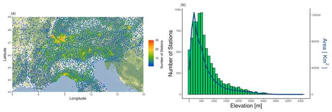
The rain-gauge network is characterised by higher spatial resolution, and longer time extent. Air temperature stations show a lower density, particularly in the area surrounding the Alps. The area including Croatia and Bosnia-Herzegovina exhibits the lowest density, due to restrictions of data providers.
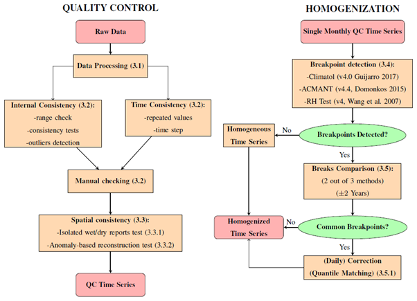
The collected data were tested for quality with a rigorous quality control (QC) procedure aiming to identify most of the issues in data recordings. This procedure involves the testing of internal and temporal consistency of time series, including a manual checking strongly recommended mostly for the validation of identified statistical outliers. The last part of QC procedure studies the spatial consistency of time series, comparing data of each time series with those of a set of neighbouring stations.
Quality checked time series are then tested for homogeneity by running three automatic methods, i.e. Climatol, ACMANT and RH Test. The results of each method are compared and, in case a single breakpoint is identified by at least two out of three methods, the related inhomogeneous periods are corrected using the quantile matching method. Our efforts aimed to homogenize two thirds of air temperature and one fourth of precipitation time series, strongly reducing the heterogeneity of the dataset. The twofold QC–homogenization process adopted here is illustrated by the flow chart in the Figure below.
Future Outcomes
This new daily observational dataset developed is useful as a tool for better understanding Alpine climate changes over recent decades and improving the reliability of model simulations and future scenarios. The procedure developed within this work can be readily implemented over other areas or time periods. Future research activities will be dedicated to improving the EEAR-Clim dataset including measurements of other essential climate variables (e.g. relative humidity, wind speed, solar radiation, or snow depth), and expanding the data coverage also beyond the last 60 years, further enriching its utility for integrated climate assessments.